


Not sure where to go riding this summer? 😎
Don't panic—we've found plenty of cool spots where you can ride and soak up the sun.
The best tip EVER? Ask our community! You guys have been amazing, sharing all your BEST bike routes! 🔥
✨ Hold on tight—here we go with the best cycling spots in France’s mountainous regions!

💥 The first one is located just outside Lyon.
It’s the perfect playground for cyclists, with plenty of (small) hills to climb (Mont Verdun 626 m, Mont Thou 611 m, and Mont Cindre 470 m).
🤔 How's the ride going?
1️⃣Start at the Saône riverbank bike path, right behind Saint-Jean Cathedral. From there, it’s straight aaaall the way! Stay on this side of the river until you reach the Collonges Bridge, past the Paul Bocuse Abbey.
2️⃣ Follow the road from Collonges to the charming village of Saint-Cyr-au-Mont-d’Or.
3️⃣ Next, head toward Saint-Didier-au-Mont-d'Or ➡️ Saint-Romain-au-Mont-d'Or or Albigny-sur-Saône, to begin your ascent to the peaks like the queen you are.


💥 The second one is located northwest of Annecy.
What is La Mandallaz? It’s a small, 8-kilometer-long pre-Alpine mountain range that rises to an elevation of 929 meters and offers breathtaking scenery!
🤔 How's the ride going?
1️⃣ LeaveAnnecy and head toward Meythet. Once you arrive in Meythet, you’ll need to make your way to Epagny, the junction where the loop begins.
2️⃣Next, head toSillingy and pass through La Balme-de-Sillingy via "the schoolchildren's path" (a nice little route for kids who bike to school).
3️⃣At the Balme roundabout, take the uphill section of RD3, then RD203 toward Cercier. After this scenic stretch, all you have to do is head downhill along Route d'Allonger to pass through Rossy.
4️⃣ Here we are at the most spectacular part of the route: a long descent with views of Annecy, Parmelan, La Tournette, and Les Bauges!
5️⃣ You’llpass through Mandallaz and then Les Genoux as you ride along Route de Ferrière. You’ll head down toward Chantemerle and Les Burnets, then take Route de la Montagne to reach Les Pourras. Stay on this road until you reach the connecting town of Epagny.
6️⃣ Since you’re heading back to Meythet and then returning to Annecy, your starting point.
We've come full circle! 🔥


💥 The third is located on the western shore of Lake Annecy.
Le Semnoz is the mountain where you can ride all the way to the top!
💡Route: approximately 56 km
🤔 How's the ride going?
1️⃣ You start right away on the Annecy bike path for 8 km, all the way to Saint-Jorioz
2️⃣ Then you continue along a leisurely road to Saint-Eustache on the way to Col de Leschaux.
Just 16 kilometers to the summit—you can do it! 💪
3️⃣ Keep riding and riding all the way to Semnoz.
This route will take you to the best viewpoints overlooking Lake Annecy! 🏞
The ride back down to Annecy is a long 20-kilometer descent through the forest—just what you need to recharge your batteries! 🌳


💥 The fourth is located in the center of the Hérault department.
Have you ever heard of Lake Salagou?
You'll be able to cycle all the way around the lake on a 32.4-kilometer route with 395 meters of elevation gain. 😎
It's the perfect time to enjoy the beautiful scenery!
🤔 How's the ride going?
1️⃣ Starting point: Start at the "Lac du Salagou" parking lot on the D156E4.
2️⃣ From there, head clockwise along the beach and then onto small shaded trails—you’ll even get to cross some streams! A short climb follows to reach a paved road. You’ll pass by a peninsula to reach the D156. Then stay on the trail for 1.5 km until you reach a crossroads.
3️⃣ Keep going straight ahead, following the marked trail. Stay on this path until you reach the launch site (Rives d’Octon). Once you’re facing the “Le Mas de Riri” campground, continue your ride by following the trail markers. Cross the campground, keeping an eye on the markers. You’ll eventually reach the village of Celles, on the lakefront.
4️⃣ Before reaching the village, look for the marked trail heading north and continue until you reach the road, then turn right onto the trail. At the intersection, stay on the trail and go around the hill until you reach the Vailhès parking lot.
5️⃣ Ride along the lake and continue on to the Notre-Dame des Clans Chapel, a pilgrimage site every year on August 15. Don’t forget to take in the views of the lake and the surrounding hills before heading back down the paved road to the hamlet of Mas Audran.
6️⃣ Finally, leave the hamlet by heading down the valley. Walk past the dam and stay on the road. Look for the trail that branches off to the right and follows the fence to the Clermont riverside parking lot—and you’re done. ✅
Directions to the lake parking lot:
➡️ On the A75, take Exit 37, “Clermont-l’Hérault.” Drive through the town toward Bédarieux, then follow the signs for “Lac du Salagou.” Parking is free along the lake’s shores! 🔥

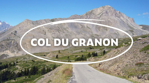
💥 The fifth one is located near Briançon.
The climb up the Col du Granon is 17 km long and reaches an altitude of 2,400 meters. 🤩
That's not all—it's one of the toughest mountain passes (average gradient of 10%).
The descent is divided into two parts:
➡️ The first part is fast but rough (forest trail). Watch out for flat tires. 🥵
➡️ Thesecond section is very technical (overhanging rock faces, scree, and loose rocks).
🤔 How's the ride going?
1️⃣ Leave Briançon via Avenue du Professeur Forgues and take the D1091 toward Saint Chaffrey.
2️⃣ Next, take Avenue de Savoie and turn right onto Route du Pont Levis, which leads to Saint Chaffrey.
3️⃣ Follow the road through Saint Chaffrey until you reach the Granon Road.
4️⃣ Drive along the Granon Road, following the D234.
5️⃣ You’ll reach the end of the Granon Road at the Col du Granon, where you’ll find a snack bar on the left side of the pass as well as a parking lot at the end.
6️⃣ Finally, take the same route back to Briançon.

That's it for now! 🔥
Don't forget to stay tuned so you don't miss out on the great itineraries we'll be sharing with you soon!
Before you go ➡️ If you have any ideas for itineraries or suggestions for us, please contact us at [email protected] or directly on Instagram at Wilma.cc!
See you soon! 🌈
